Home > Arts > Artists > H > Jodocus Hondius
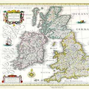
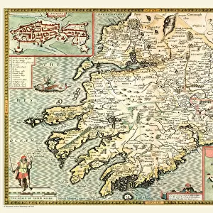
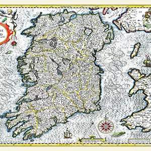
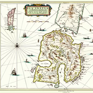
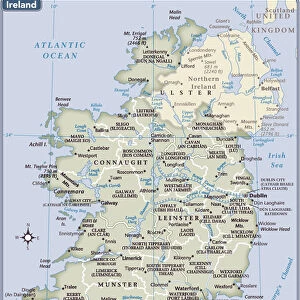
Old Map of Ireland 1635 by Willem & Johan Blaeu from the Theatrum Orbis Terrarum

![]()
Wall Art and Photo Gifts from MapSeeker
Old Map of Ireland 1635 by Willem & Johan Blaeu from the Theatrum Orbis Terrarum
This detailed and most attractive reproduction map of Ireland has been carefully art worked from a scan of an antique original. The famous firm of Dutch cartographers and publishers was established in the late 16th century by Willem Janszoon Blaeu in Amsterdam. Blaeu was a maker of globes and scientific instruments and purchased some of his early map plates from Jodocus Hondius. From this small beginning was to emerge one of the largest and most prolific map publishing houses of the seventeenth century
Welcome to the Mapseeker Image library and enter an historic gateway to one of the largest on-line collections of Historic Maps, Nostalgic Views, Vista's and Panorama's from a World gone by.
Media ID 20347737
Blaeu Blaeu Family Blaue Map Historic Map Johan Blaeu Johan Blaeu Map Old Blaue Map
FEATURES IN THESE COLLECTIONS
> Arts
> Artists
> B
> Willem Blaeu
> Arts
> Artists
> H
> Jodocus Hondius
> Arts
> Photorealistic artworks
> Detailed art pieces
> Masterful detailing in art
> Europe
> Republic of Ireland
> Maps
> Maps and Charts
> Early Maps
> Maps and Charts
> Related Images
> Maps and Charts
> Willem Janszoon Blaeu
> MapSeeker
> Maps from the British Isles
> Ireland and Provinces PORTFOLIO
EDITORS COMMENTS
This exquisite print showcases an Old Map of Ireland from 1635, meticulously reproduced from the original by Willem and Johan Blaeu. The Blaeu family, renowned Dutch cartographers and publishers, established their firm in Amsterdam during the late 16th century. Willem Janszoon Blaeu initially specialized in crafting globes and scientific instruments before venturing into map production. The Theatrum Orbis Terrarum served as a significant milestone for the Blaeu publishing house, catapulting them to become one of the largest and most prolific map producers of the seventeenth century. This particular reproduction captures the intricate details of Ireland's geography with utmost precision. As you delve into this historic map, you'll be transported back to a time when exploration was at its peak. Trace your finger along ancient coastlines and follow winding rivers that have shaped Ireland's landscape for centuries. Discover long-forgotten towns, castles perched atop hillsides, and vibrant cities steeped in history. Whether you are an avid historian or simply captivated by cartographic artistry, this old Irish map will undoubtedly ignite your curiosity about Ireland's rich past. Display it proudly on your wall as a testament to both the craftsmanship of the Blaeu family and Ireland's enduring allure throughout time.
MADE IN THE USA
Safe Shipping with 30 Day Money Back Guarantee
FREE PERSONALISATION*
We are proud to offer a range of customisation features including Personalised Captions, Color Filters and Picture Zoom Tools
SECURE PAYMENTS
We happily accept a wide range of payment options so you can pay for the things you need in the way that is most convenient for you
* Options may vary by product and licensing agreement. Zoomed Pictures can be adjusted in the Cart.