Home > Arts > Artists > H > Jodocus Hondius
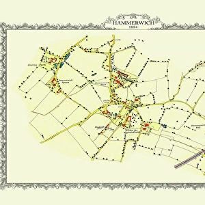
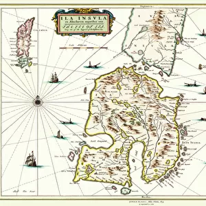
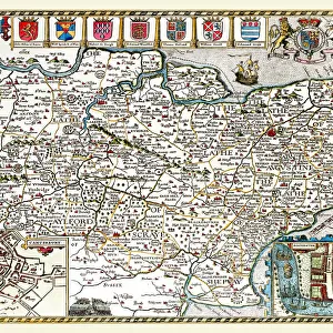
Old County Map of Staffordshire 1648 by Johan Blaeu from the Atlas Novus

![]()
Wall Art and Photo Gifts from MapSeeker
Old County Map of Staffordshire 1648 by Johan Blaeu from the Atlas Novus
This detailed and most attractive reproduction map of Staffordshire has been carefully art worked from a scan of an antique original. The famous firm of Dutch cartographers and publishers was established in the late 16th century by Willem Janszoon Blaeu in Amsterdam. Blaeu was a maker of globes and scientific instruments and purchased some of his early map plates from Jodocus Hondius. From this small beginning was to emerge one of the largest and most prolific map publishing houses of the seventeenth century
Welcome to the Mapseeker Image library and enter an historic gateway to one of the largest on-line collections of Historic Maps, Nostalgic Views, Vista's and Panorama's from a World gone by.
Media ID 20347681
Blaeu Blaeu Family Blaue Map County Map County Map Of England English County Map Historic Map Johan Blaeu Johan Blaeu Map Old Blaue Map Old County Map Old English County Map Staffordshire
FEATURES IN THESE COLLECTIONS
> Arts
> Artists
> B
> Willem Blaeu
> Arts
> Artists
> H
> Jodocus Hondius
> Arts
> Photorealistic artworks
> Detailed art pieces
> Masterful detailing in art
> Europe
> United Kingdom
> England
> Maps
> Europe
> United Kingdom
> England
> Staffordshire
> Related Images
> Maps and Charts
> Early Maps
> Maps and Charts
> Related Images
> Maps and Charts
> Willem Janszoon Blaeu
> MapSeeker
> Maps from the British Isles
> England and Counties PORTFOLIO
EDITORS COMMENTS
This beautifully crafted reproduction of the "Old County Map of Staffordshire 1648" by Johan Blaeu takes us back in time to explore the historical landscape of this English county. Carefully art worked from a scan of an antique original, this detailed and attractive map showcases the expertise and craftsmanship that made the Blaeu family renowned cartographers and publishers. Established in Amsterdam during the late 16th century by Willem Janszoon Blaeu, this famous Dutch firm initially focused on producing globes and scientific instruments. However, their passion for cartography led them to acquire map plates from Jodocus Hondius, setting them on a path to become one of the largest and most prolific map publishing houses of the seventeenth century. The "Old County Map of Staffordshire" offers a glimpse into its rich history, depicting towns, villages, rivers, forests, and other geographical features with remarkable accuracy for its time. This historic document serves as a valuable resource for researchers, historians, or anyone fascinated by Staffordshire's past. Whether you are studying local history or simply appreciate vintage maps as decorative pieces with stories to tell, this print is sure to captivate your imagination. Transport yourself back centuries ago as you trace ancient roads or discover forgotten landmarks through this meticulously reproduced piece. Let it serve as a reminder that even in our modern world filled with advanced technology and satellite imagery; there is still something magical about exploring history through these old maps.
MADE IN THE USA
Safe Shipping with 30 Day Money Back Guarantee
FREE PERSONALISATION*
We are proud to offer a range of customisation features including Personalised Captions, Color Filters and Picture Zoom Tools
SECURE PAYMENTS
We happily accept a wide range of payment options so you can pay for the things you need in the way that is most convenient for you
* Options may vary by product and licensing agreement. Zoomed Pictures can be adjusted in the Cart.