Home > Europe > United Kingdom > England > London > Art > Theatre
Political Map of Africa, 1914, (1920). Creator: John Bartholomew & Son
. Creator: John Bartholomew & Son")
![]()
Wall Art and Photo Gifts from Heritage Images
Political Map of Africa, 1914, (1920). Creator: John Bartholomew & Son
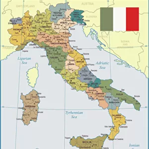
Political Map of Africa, 1914, (1920). Colonial possessions in Africa at the start of the First World War. British colonies are pink, French - green, German - orange, Portuguese - purple, Italian - brown. From " The Great World War - A History" Volume I, edited by Frank A Mumby. [The Gresham Publishing Company Ltd, London, c1920]
Heritage Images features heritage image collections
Media ID 19174246
© The Print Collector/Heritage Images
Bartholomew Bartholomew And Co Bartholomew Co Bartholomew John Son Colonies Colony Frank Arthur Frank Arthur Mumby French Empire German Empire Gresham Publishing Co Ltd Gresham Publishing Company Imperial Imperialism Jg Bartholomew John And Son John Bartholomew And Co John Bartholomew And Son John Bartholomew And Son Ltd John Bartholomew Co John Bartholomew Son John Bartholomew Son Ltd John Son Keystone Archives Mumby Mumby Frank Arthur The Great World War A History Theatre Of War British Empire Portuguese Empire
FEATURES IN THESE COLLECTIONS
> Arts
> Artists
> B
> John Brown
> Europe
> Portugal
> Politics
> Europe
> Portugal
> Related Images
> Europe
> United Kingdom
> England
> London
> Art
> Theatre
EDITORS COMMENTS
This print showcases the "Political Map of Africa, 1914" created by John Bartholomew & Son in 1920. The map vividly depicts the colonial possessions in Africa at the onset of the First World War, offering a glimpse into the intricate web of imperial powers that dominated the continent during this period. The map is color-coded to distinguish between various colonial empires. British colonies are represented by a striking shade of pink, while French territories are depicted in vibrant green. German possessions stand out with their bold orange hue, and Portuguese colonies are marked with regal purple. Lastly, Italian territories are denoted by an earthy brown tone. Taken from "The Great World War - A History" edited by Frank A Mumby and published by The Gresham Publishing Company Ltd in London around 1920, this image provides valuable insight into the political landscape of Africa during one of history's most significant conflicts. As we observe this historical artifact today, it serves as a reminder of Europe's scramble for African territories and highlights how these power dynamics played a crucial role in shaping events leading up to World War I. This visually stunning map invites us to reflect on the impact of imperialism and colonialism on both continents involved – Africa and Europe – ultimately leaving an indelible mark on world history.
MADE IN THE USA
Safe Shipping with 30 Day Money Back Guarantee
FREE PERSONALISATION*
We are proud to offer a range of customisation features including Personalised Captions, Color Filters and Picture Zoom Tools
SECURE PAYMENTS
We happily accept a wide range of payment options so you can pay for the things you need in the way that is most convenient for you
* Options may vary by product and licensing agreement. Zoomed Pictures can be adjusted in the Cart.