Home > Arts > Artists > A > John White Alexander
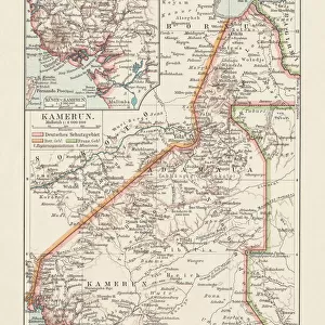
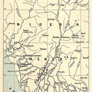
Map Showing the German Cameroon Colony, 1916. Creator: Unknown

![]()
Wall Art and Photo Gifts from Heritage Images
Map Showing the German Cameroon Colony, 1916. Creator: Unknown
Map Showing the German Cameroon Colony, 1916. German Cameroon was an African colony of the German Empire from 1884 to 1916. Following Germanys defeat, the Treaty of Versailles divided the territory between Great Britain and France. From " The War Illustrated Album De Luxe - Volume IV. The Summer Campaign - 1915", edited by J. A. Hammerton. [The Amalgamated Press, Limited, London, 1916]
Heritage Images features heritage image collections
Media ID 19661303
© The Print Collector/Heritage Images
Album Amalgamated Press Amalgamated Press Limited Amalgamated Press Ltd Cameroon Congo Congo Africa Democratic Republic Of The Congo German Empire Hammerton Hammerton J A Hammerton Ja Hammerton Sir John Alexander J A Hammerton Ja Hammerton John Hammerton Nigeria Sir John Alexander Sir John Alexander Hammerton Sir John Hammerton Strategic Strategy Summer Campaign 1915 Territorial Territory The Amalgamated Press The War Illustrated
FEATURES IN THESE COLLECTIONS
> Africa
> Cameroon
> Related Images
> Africa
> Democratic Republic of the Congo
> Related Images
> Africa
> Nigeria
> Related Images
> Africa
> Republic of the Congo
> Maps
> Arts
> Artists
> A
> John White Alexander
> Arts
> Artists
> W
> John White
EDITORS COMMENTS
This print showcases a historical map titled "Map Showing the German Cameroon Colony, 1916". Created by an unknown artist, this map depicts the African colony of German Cameroon during its existence from 1884 to 1916. The German Empire ruled over this territory until their defeat in World War I, which led to the division of the region between Great Britain and France through the Treaty of Versailles. The photograph is sourced from "The War Illustrated Album De Luxe - Volume IV. The Summer Campaign - 1915" edited by J. A. Hammerton and published by The Amalgamated Press Limited in London in 1916. It captures a significant moment in history when colonial powers were vying for control over African territories. The map represents not only a geographical depiction but also symbolizes concepts such as colonialism, strategy, and territorial disputes. It highlights how Africa was divided among European powers during this period. Although we do not know who specifically created this map, it serves as a valuable historical artifact that sheds light on Germany's presence in Africa during the early 20th century. This image offers viewers an opportunity to explore the impact of World War I on global politics and colonization efforts at that time.
MADE IN THE USA
Safe Shipping with 30 Day Money Back Guarantee
FREE PERSONALISATION*
We are proud to offer a range of customisation features including Personalised Captions, Color Filters and Picture Zoom Tools
SECURE PAYMENTS
We happily accept a wide range of payment options so you can pay for the things you need in the way that is most convenient for you
* Options may vary by product and licensing agreement. Zoomed Pictures can be adjusted in the Cart.