Home > Europe > France > Paris > Maps
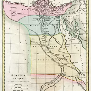
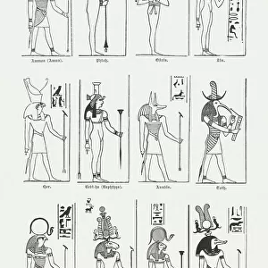
Map of Ancient Egypt, 1890. Creator: Unknown

![]()
Wall Art and Photo Gifts from Heritage Images
Map of Ancient Egypt, 1890. Creator: Unknown
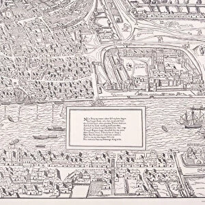
Map of Ancient Egypt, 1890. For almost 30 centuries from its unification around 3100 BC to its conquest by Alexander the Great in 332 BC, ancient Egypt was the preeminent civilization in the Mediterranean world. From " Cassells Illustrated Universal History, Vol. I - Early and Greek History", by Edmund Ollier. [Cassell and Company, Limited, London, Paris and Melbourne, 1890]
Heritage Images features heritage image collections
Media ID 19065741
© The Print Collector/Heritage Images
4th Century Bc Ancient Egypt Cassell And Cassell And Co Cassell And Company Cassells Cassells Illustrated Universal History Civilisation Early And Greek History Edmund Edmund Ollier Kingdom Nile North Africa Ollier River Nile The Nile Cassell And Company Ltd Mizraim
FEATURES IN THESE COLLECTIONS
> Africa
> Egypt
> Related Images
> Arts
> Literature
> Illustration
> Arts
> Literature
> Arts
> Minimalist artwork
> Monochrome artwork
> Fine art
> Arts
> Minimalist artwork
> Monochrome artwork
> Monochrome paintings
> Europe
> France
> Paris
> Maps
> Europe
> Greece
> Related Images
EDITORS COMMENTS
This print showcases a remarkable "Map of Ancient Egypt, 1890". Created by an unknown artist, this map provides a glimpse into the rich history and geographical features of one of the most influential civilizations in the Mediterranean world. For nearly three millennia, from its unification around 3100 BC to its conquest by Alexander the Great in 332 BC, ancient Egypt reigned as a preeminent civilization. This antique map offers us an opportunity to explore the kingdom's vast territory along the majestic River Nile. Taken from "Cassells Illustrated Universal History, Vol. I - Early and Greek History" authored by Edmund Ollier in London, Paris, and Melbourne in 1890; it is evident that this piece holds immense historical significance. The intricate engravings on this monochrome illustration depict key locations such as Mizraim (Egypt) and other parts of North Africa. As we delve into this mesmerizing artwork, we are transported back to a time when literature, arts, and culture flourished within ancient Egypt's borders. It serves as a testament to their advanced civilization which left an indelible mark on human history. Preserved through time with utmost care by The Print Collector (not affiliated with any commercial use), this vintage map allows us to appreciate both the artistic beauty and educational value it possesses. A true treasure for history enthusiasts seeking insight into one of humanity's greatest achievements – Ancient Egypt.
MADE IN THE USA
Safe Shipping with 30 Day Money Back Guarantee
FREE PERSONALISATION*
We are proud to offer a range of customisation features including Personalised Captions, Color Filters and Picture Zoom Tools
SECURE PAYMENTS
We happily accept a wide range of payment options so you can pay for the things you need in the way that is most convenient for you
* Options may vary by product and licensing agreement. Zoomed Pictures can be adjusted in the Cart.