Home > Europe > Montenegro > Maps
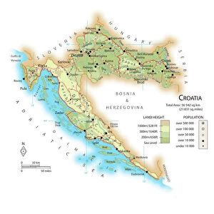
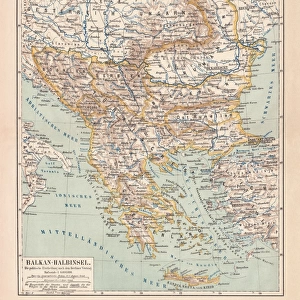
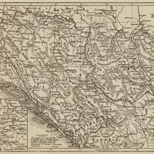
Map of the Kingdom of Dalmatia (present-day Croatia and Montenegro)
")
![]()
Wall Art and Photo Gifts from Fine Art Finder
Map of the Kingdom of Dalmatia (present-day Croatia and Montenegro)
LRI4711368 Map of the Kingdom of Dalmatia (present-day Croatia and Montenegro), on the coast of the Gulf of Venice (Adriatic Sea) (Engraving, 1717) by Nolin, Jean-Baptiste (c.1657-1708); Private Collection; (add.info.: Map of the Kingdom of Dalmatia (present-day Croatia and Montenegro), on the coast of the Gulf of Venice (Adriatic Sea) - Engraving from the atlas le theatre du monde, 1717, by Jean Baptiste Nolin (1686-1762) - Map of the Kingdom of Dalmatia - From " Le Theatre du Monde" 1717 by Jean-Baptiste Nolin); Luisa Ricciarini; French, out of copyright
Media ID 22278606
© Luisa Ricciarini / Bridgeman Images
Atlas Book Balkans Croatia Montenegro Geographical Map
FEATURES IN THESE COLLECTIONS
> Europe
> Croatia
> Related Images
> Europe
> Montenegro
> Maps
> Europe
> Montenegro
> Posters
> Europe
> Montenegro
> Related Images
> Fine Art Finder
> Artists
> Jean-Baptiste Nolin
> Maps and Charts
> Montenegro
EDITORS COMMENTS
This engraving, titled "Map of the Kingdom of Dalmatia" takes us back to the year 1717 and offers a glimpse into the historical geography of present-day Croatia and Montenegro. Created by Jean-Baptiste Nolin, a renowned French cartographer, this intricate map showcases the coastal region along the Gulf of Venice (Adriatic Sea). The level of detail in this print is truly remarkable. Every contour line, river, and city is meticulously engraved onto the paper, providing an accurate representation of this significant area in Europe. As we explore this map further, we can see how it captures not only geographical features but also political boundaries. Dalmatia's strategic location on the Balkan Peninsula has made it a coveted territory throughout history. This map allows us to appreciate its importance as it highlights key cities such as Split and Dubrovnik (Ragusa). It serves as a testament to centuries-old trade routes that connected these coastal towns with neighboring regions. Preserved within private collections today, this engraving from Nolin's atlas book "Le Theatre du Monde" transports us back in time. Its ageless charm reminds us of the enduring significance of cartography in understanding our world's past. Luisa Ricciarini expertly captures every detail through her lens while photographing this historical artifact for Fine Art Finder. Her skillful composition ensures that viewers can appreciate both the artistic beauty and educational value held within this remarkable piece from centuries ago.
MADE IN THE USA
Safe Shipping with 30 Day Money Back Guarantee
FREE PERSONALISATION*
We are proud to offer a range of customisation features including Personalised Captions, Color Filters and Picture Zoom Tools
SECURE PAYMENTS
We happily accept a wide range of payment options so you can pay for the things you need in the way that is most convenient for you
* Options may vary by product and licensing agreement. Zoomed Pictures can be adjusted in the Cart.