Home > Architecture > Bridges > Brooklyn Bridge
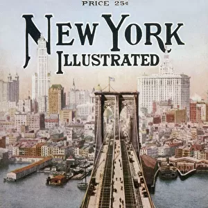
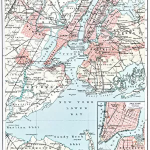
Old Map of New York United States of America 1851 by John Tallis

![]()
Wall Art and Photo Gifts from MapSeeker
Old Map of New York United States of America 1851 by John Tallis
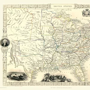
This is a most attractive yet detailed plan 1851 by John Tallis of New York and districts of Jersey, Panovia, Hoboken, Brooklyn and Williamsburgh in the U.S.A. The numerous, identified ferries are flourishing with increasing traffic across the Hudson and East River, the great bridges have not yet arrived. Many individual docking ports and Packets are named. The plan of New York has been beautifully finished with six illustrations. To the top of the plan a view towards Brooklyn with sailing boats and steamers. To the top right City Hall and the Custom House. At the bottom a panoramic view across to New York from Williamsburg and a view of the Narrows from Fort Hamilton. There is New York Steamer to the top left
Welcome to the Mapseeker Image library and enter an historic gateway to one of the largest on-line collections of Historic Maps, Nostalgic Views, Vista's and Panorama's from a World gone by.
Media ID 20347586
Historic Map John Tallis John Tallis Map Old Town Plan Tallis Map
FEATURES IN THESE COLLECTIONS
> Architecture
> Bridges
> Brooklyn Bridge
> Arts
> Artists
> T
> John Tallis
> Arts
> Photorealistic artworks
> Detailed art pieces
> Masterful detailing in art
> Europe
> United Kingdom
> Scotland
> Strathclyde
> Hamilton
> Maps and Charts
> Related Images
> MapSeeker
> Maps of the Americas
> Maps of the United States of America
> North America
> United States of America
> New Jersey
> Jersey City
> North America
> United States of America
> New York
> New York
> Bridges
> Brooklyn Bridge
> North America
> United States of America
> New York
> New York
> Bridges
> Related Images
EDITORS COMMENTS
This print showcases an exquisite and meticulously detailed plan of New York City in 1851, crafted by the talented cartographer John Tallis. The map encompasses not only New York but also neighboring districts such as Jersey, Panovia, Hoboken, Brooklyn, and Williamsburgh within the United States of America. As one explores this enchanting piece of history, they will notice the bustling ferries traversing the Hudson and East River, long before the advent of grand bridges that now grace these waters. Every individual docking port and Packet is thoughtfully labeled on this map, providing a glimpse into the thriving maritime activity of that era. Additionally, six beautifully illustrated vignettes adorn this masterpiece: sailing boats and steamers dotting the view towards Brooklyn at its top; City Hall and Custom House majestically positioned to its top right; a panoramic vista across to New York from Williamsburg gracing its bottom section; and finally, a mesmerizing depiction of Fort Hamilton offering a view of the Narrows. Immerse yourself in this historic treasure which offers an insight into how New York City appeared over 150 years ago. With its remarkable attention to detail and artistic flair evident throughout every inch of this work by John Tallis – renowned for his exceptional craftsmanship – it serves as both a testament to our rich past while igniting curiosity about how much has changed since then.
MADE IN THE USA
Safe Shipping with 30 Day Money Back Guarantee
FREE PERSONALISATION*
We are proud to offer a range of customisation features including Personalised Captions, Color Filters and Picture Zoom Tools
SECURE PAYMENTS
We happily accept a wide range of payment options so you can pay for the things you need in the way that is most convenient for you
* Options may vary by product and licensing agreement. Zoomed Pictures can be adjusted in the Cart.