Home > Europe > United Kingdom > England > London > Towns > Putney
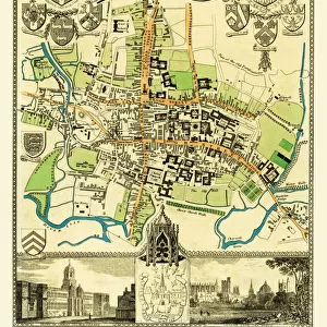
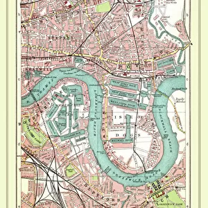
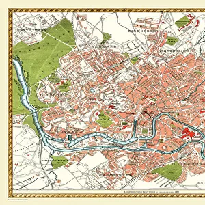
Old Street Map of Chelsea, Putney and River Thames 1908

![]()
Wall Art and Photo Gifts from MapSeeker
Old Street Map of Chelsea, Putney and River Thames 1908
Detailed colour Street Plan of London from 1908 covering the area around Chelsea, Putney and the River Thames. The image has been remastered from Bartholomews Handy Atlas of London and Suburbs 1908
Welcome to the Mapseeker Image library and enter an historic gateway to one of the largest on-line collections of Historic Maps, Nostalgic Views, Vista's and Panorama's from a World gone by.
Media ID 20347795
© Mapseeker Publishing Ltd, Collins Bartholomew Ltd
London Map London Street Plan Map Of Central London Map Of London Old London Street Map Old Map Of London Central Street Map Of London Street Plan Putney
FEATURES IN THESE COLLECTIONS
> Arts
> Photorealistic artworks
> Detailed art pieces
> Masterful detailing in art
> Europe
> United Kingdom
> England
> London
> Boroughs
> Kensington and Chelsea
> Europe
> United Kingdom
> England
> London
> River Thames
> Europe
> United Kingdom
> England
> London
> Towns
> Chelsea
> Europe
> United Kingdom
> England
> London
> Towns
> Putney
> Maps and Charts
> Related Images
> MapSeeker
> British Town And City Plans
> English & Welsh PORTFOLIO
EDITORS COMMENTS
This print takes us back in time to the bustling streets of Chelsea, Putney, and the iconic River Thames in 1908. A meticulously detailed street plan of London from that era, this image has been beautifully remastered from Bartholomews Handy Atlas of London and Suburbs 1908 by John Bartholomew. As we gaze upon this old map of central London, we are transported to a bygone era when horse-drawn carriages traversed these historic streets. The vibrant colors bring life to the intricate network of roads, alleyways, and buildings that once defined these neighborhoods. The charm of Chelsea and Putney is palpable as we explore their winding lanes and discover hidden gems along the way. This snapshot captures not only the physical layout but also offers a glimpse into the daily lives of those who called this area home over a century ago. And then there's the majestic River Thames flowing through it all like an artery connecting these vibrant communities. Its presence on this map reminds us of its historical importance as a vital trade route and source of inspiration for countless artists throughout history. Thanks to MapSeeker Publishing's dedication to preserving our past, we can now admire this remarkable piece of history with fresh eyes. Whether you're a lover of maps or simply intrigued by London's rich heritage, this old street map is sure to captivate your imagination and transport you back in time.
MADE IN THE USA
Safe Shipping with 30 Day Money Back Guarantee
FREE PERSONALISATION*
We are proud to offer a range of customisation features including Personalised Captions, Color Filters and Picture Zoom Tools
SECURE PAYMENTS
We happily accept a wide range of payment options so you can pay for the things you need in the way that is most convenient for you
* Options may vary by product and licensing agreement. Zoomed Pictures can be adjusted in the Cart.