Home > Animals > Mammals > Cats (Wild) > Tiger
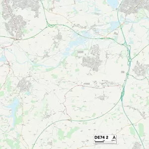
CT Hartford Granby Vector Road Map

![]()
Wall Art and Photo Gifts from Fine Art Storehouse
CT Hartford Granby Vector Road Map
CT Hartford Granby Vector Road Map. All source data is in the public domain. U.S. Census Bureau Census Tiger. Used Layers: areawater, linearwater, roads, rails, cousub, pointlm, uac10
Unleash your creativity and transform your space into a visual masterpiece!
Frank Ramspott
Media ID 20688081
© Frank Ramspott, all rights reserved
City Map Computer Graphic Connecticut County Digital Composite District Geographical Border Granby Hartford Hungary Road Map Text Vector Village Digitally Generated Image Meadowgate
FEATURES IN THESE COLLECTIONS
> Animals
> Mammals
> Cats (Wild)
> Tiger
> Animals
> Mammals
> Muridae
> Water Mouse
> Arts
> Contemporary art
> Digital artwork
> Street art
> Arts
> Landscape paintings
> Waterfall and river artworks
> River artworks
> Arts
> Portraits
> Pop art gallery
> Street art portraits
> Arts
> Street art graffiti
> Digital art
> Digital paintings
> Europe
> Hungary
> Lakes
> Related Images
> Europe
> Hungary
> Related Images
> Fine Art Storehouse
> Map
> Reference Maps
EDITORS COMMENTS
This print showcases the intricate details of the CT Hartford Granby Vector Road Map. Created by talented artist Frank Ramspott, this digitally generated image is a true masterpiece of cartography and design. With no people in sight, the focus lies solely on the vibrant colors and precise lines that bring this map to life. Using various layers sourced from the U. S. Census Bureau Census Tiger, including areawater, linearwater, roads, rails, cousub, pointlm, and uac10 data sets - every element has been carefully incorporated into this visually stunning composition. From geographical borders to city streets and rivers to lakes, every village and town within Hartford County can be explored through this detailed road map. The inclusion of text adds an informative touch to the artwork as it labels significant landmarks such as Crag Mountain, Goodrichville, Hungary Village, Pegville, Meadowgate Village, Chatsworth Village, Firetown, and Barkhamsted among others. With its use of vector graphics and digital compositing techniques, this print seamlessly combines physical geography with computer-generated artistry, resulting in a visually striking representation of Connecticut's landscape. Perfect for any lover of maps or those with an appreciation for fine art, this print is sure to captivate viewers with its meticulous attention to detail. It serves as both a functional tool for navigation purposes while also being aesthetically pleasing enough to serve as a beautiful piece of wall decor.
MADE IN THE USA
Safe Shipping with 30 Day Money Back Guarantee
FREE PERSONALISATION*
We are proud to offer a range of customisation features including Personalised Captions, Color Filters and Picture Zoom Tools
SECURE PAYMENTS
We happily accept a wide range of payment options so you can pay for the things you need in the way that is most convenient for you
* Options may vary by product and licensing agreement. Zoomed Pictures can be adjusted in the Cart.