Home > Aerial Photography > Related Images
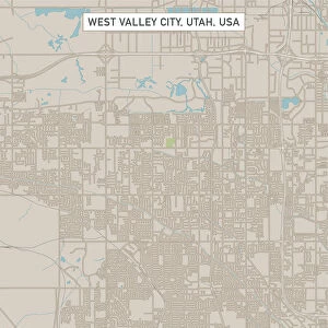
Sandy Utah US City Street Map

![]()
Wall Art and Photo Gifts from Fine Art Storehouse
Sandy Utah US City Street Map
Vector Illustration of a City Street Map of Sandy, Utah, USA. Scale 1:60, 000.
All source data is in the public domain.
U.S. Geological Survey, US Topo
Used Layers:
USGS The National Map: National Hydrography Dataset (NHD)
USGS The National Map: National Transportation Dataset (NTD)
Unleash your creativity and transform your space into a visual masterpiece!
Frank Ramspott
Media ID 15054963
© Frank Ramspott, all rights reserved
Aerial View City Map Computer Graphic Directly Above Downtown District Gray Jordan River Road Map Sandy Text Utah Digitally Generated Image Green Color White Color
FEATURES IN THESE COLLECTIONS
> Aerial Photography
> Related Images
> Animals
> Insects
> Hemiptera
> Green Scale
> Arts
> Contemporary art
> Digital artwork
> Street art
> Arts
> Landscape paintings
> Waterfall and river artworks
> River artworks
> Arts
> Portraits
> Pop art gallery
> Street art portraits
> Arts
> Street art graffiti
> Digital art
> Digital paintings
> Arts
> Street art graffiti
> Digital art
> Vector illustrations
> Asia
> Jordan
> Lakes
> Related Images
> Fine Art Storehouse
> Map
> Street Maps
> Fine Art Storehouse
> Map
> USA Maps
> Maps and Charts
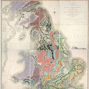
> Geological Map
EDITORS COMMENTS
This print showcases a meticulously designed city street map of Sandy, Utah, USA. With a scale of 1:60,000, this vector illustration offers an intricate depiction of the city's layout and features. The image is a result of combining various layers from reliable sources such as the U. S. Geological Survey (USGS) and their National Map datasets including the National Hydrography Dataset (NHD) and National Transportation Dataset (NTD). The map highlights key elements like the Jordan River, downtown district, lake, river, streets, and roads that make up Sandy's urban landscape. Its expertly crafted cartography design brings together different shades of gray for roads and buildings while incorporating vibrant colors like blue for water bodies and green for parks or open spaces. Digitally generated with precision by Frank Ramspott using computer graphics techniques, this aerial view presents an accurate representation directly from above. The absence of people in this color image allows viewers to focus solely on exploring the physical geography and layout of Sandy. With all source data in the public domain courtesy of USGS' The National Map initiative - ensuring reliability - this print serves as both an informative tool for navigation enthusiasts and a visually appealing piece suitable for any art collection or decor style.
MADE IN THE USA
Safe Shipping with 30 Day Money Back Guarantee
FREE PERSONALISATION*
We are proud to offer a range of customisation features including Personalised Captions, Color Filters and Picture Zoom Tools
SECURE PAYMENTS
We happily accept a wide range of payment options so you can pay for the things you need in the way that is most convenient for you
* Options may vary by product and licensing agreement. Zoomed Pictures can be adjusted in the Cart.