Home > Arts > Artists > B > Joan Blaeu
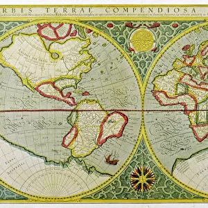
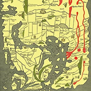
17th century world map

![]()
Wall Art and Photo Gifts from Science Photo Library
17th century world map
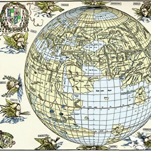
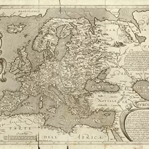
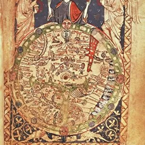
World map, published around 1664 in Amsterdam, the Netherlands, by Dutch mapmaker Joan Blaeu (c.1599- 1673). The Latin title is Nova et Accuratissima Totius Terrarum Orbis Tabula (new and accurate all world map). Blaeus maps built on those made by Mercator and Hondius in the late 16th and early 17th centuries. The Blaeu maps emphasized fine art and colours, being the most expensive of the time. Two mapmakers are shown at upper right and upper left, together with a wide variety of mythical beings. The poorly-mapped regions include the far north and south, parts of the Americas (left-hand hemisphere), and the Far East. The western coast of Australia (New Holland) was discovered in 1616
Science Photo Library features Science and Medical images including photos and illustrations
Media ID 6350811
© LIBRARY OF CONGRESS, GEOGRAPHY AND MAP DIVISION/SCIENCE PHOTO LIBRARY
1600s 17th Century Africa America Ancient Australia Cartography Continent Continents Diagram Dutch Eastern Eurasia Hemisphere Hemispheres Illustrated Inaccurate Incomplete Latin New World Old World Renaissance Western World 1664 Joan Blaeu Library Of Congress New Holland
FEATURES IN THESE COLLECTIONS
> Africa
> Related Images
> Africa
> South Africa
> Maps
> Africa
> South Africa
> Related Images
> Animals
> Mammals
> Muridae
> Western Mouse
> Arts
> Art Movements
> Renaissance Art
> Arts
> Artists
> B
> Joan Blaeu
> Asia
> East Timor
> Maps
> Asia
> East Timor
> Related Images
> Asia
> Related Images
> Europe
> Netherlands
> Amsterdam
> Maps and Charts
> Popular Maps
> Posters
> Scientific Posters
EDITORS COMMENTS
This print showcases a remarkable 17th-century world map, meticulously crafted by the renowned Dutch mapmaker Joan Blaeu. Published around 1664 in Amsterdam, this masterpiece is titled "Nova et Accuratissima Totius Terrarum Orbis Tabula" meaning "new and accurate all-world map" in Latin. Blaeu's cartographic expertise drew inspiration from the works of Mercator and Hondius, pioneers of their time. However, what set Blaeu's maps apart was his emphasis on artistic finesse and vibrant colors, making them the most coveted and expensive maps of that era. Intriguingly depicted within this ancient illustration are two skilled mapmakers positioned at the upper right and left corners. Surrounding them are an array of mythical creatures, adding a touch of whimsy to this otherwise serious endeavor. While it reflects an impressive level of detail for its time, certain regions remain imperfectly mapped. The far north and south areas, parts of the Americas (left-hand hemisphere), as well as the Far East exhibit some inaccuracies. Notably, it was only in 1616 that the western coast of Australia (known then as New Holland) was discovered. With its historical significance and exquisite artistry capturing our attention even today, this 17th-century world map serves as a testament to Blaeu's mastery in cartography during the Renaissance period. Preserved by Science Photo Library from their collection at Library of Congress, this print offers us a glimpse into our planet's past while reminding us how much we have learned about our ever-evolving world since then.
MADE IN THE USA
Safe Shipping with 30 Day Money Back Guarantee
FREE PERSONALISATION*
We are proud to offer a range of customisation features including Personalised Captions, Color Filters and Picture Zoom Tools
SECURE PAYMENTS
We happily accept a wide range of payment options so you can pay for the things you need in the way that is most convenient for you
* Options may vary by product and licensing agreement. Zoomed Pictures can be adjusted in the Cart.