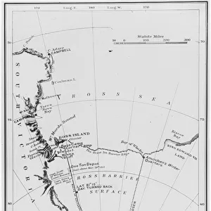
Home > North America > United States of America > New York > New York > Sights > Wall Street
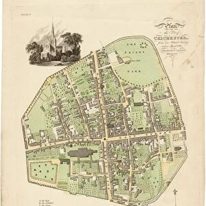
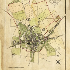
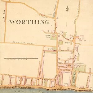
Map of Chichester within the City Walls, 1812

![]()
Wall Art and Photo Gifts from West Sussex County Council
Map of Chichester within the City Walls, 1812
Plan of the city of Chichester from an actual survey taken April 1812 by George Loader, Surveyor
Printed Maps Collection
West Sussex Record Office Ref No: PM 154
West Sussex County Council Record Office contains a fascinating history of the county of West Sussex, England
Media ID 5978153
© reserved
Priory Park East Street North Street Pallant South Street Tower Street West Street
FEATURES IN THESE COLLECTIONS
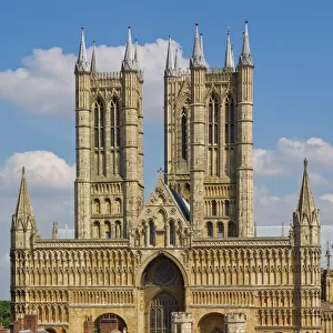
> Architecture
> Towers
> Cathedrals
> Europe
> United Kingdom
> England
> East Sussex
> Related Images
> Europe
> United Kingdom
> England
> Sussex
> Chichester
> Europe
> United Kingdom
> England
> Sussex
> Related Images
> Europe
> United Kingdom
> England
> Sussex
> South Street
> Europe
> United Kingdom
> England
> West Sussex
> Chichester
> Europe
> United Kingdom
> England
> West Sussex
> Related Images
> Historic
> Medieval architecture
> Towers and city walls
> City walls history
> Maps and Charts
> Related Images
> North America
> United States of America
> New York
> New York
> Sights
> Wall Street
> West Sussex County Council
> Urban
> West Sussex County Council
> West Sussex Record Office
> Printed Maps
EDITORS COMMENTS
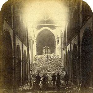
This print showcases the intricate "Map of Chichester within the City Walls, 1812" meticulously crafted by George Loader, a skilled surveyor of his time. With its rich historical significance, this map offers an invaluable glimpse into the layout and architecture of Chichester during that era. The vibrant colors used to depict Close, South Street, West Street, Priory Park, East Street, North Street, Tower Street are truly striking. Each street is intricately detailed with precision and accuracy. The drawing of the cathedral at the heart of this map serves as a focal point - a testament to its prominence in Chichester's landscape. As we delve deeper into this remarkable piece of cartography from West Sussex Record Office's Printed Maps Collection (Ref No: PM 154), it becomes evident that every element has been thoughtfully included. From landmarks like Pallant House to lesser-known corners tucked away within city walls – no detail has been overlooked. It is important to note that this print is not associated with any commercial use but rather serves as an educational resource for those interested in exploring Chichester's past. Through studying maps such as these, we gain insight into how cities evolve over time and appreciate their unique heritage. In essence, this print encapsulates both artistry and historical documentation seamlessly merged together. It invites us on a journey through time while celebrating the beauty and charm of Chichester within its ancient city walls.
MADE IN THE USA
Safe Shipping with 30 Day Money Back Guarantee
FREE PERSONALISATION*
We are proud to offer a range of customisation features including Personalised Captions, Color Filters and Picture Zoom Tools
SECURE PAYMENTS
We happily accept a wide range of payment options so you can pay for the things you need in the way that is most convenient for you
* Options may vary by product and licensing agreement. Zoomed Pictures can be adjusted in the Cart.

![Chichester St. Peter the Great [Subdeanery] tithe map, 1846-1847](/sq/479/chichester-st-peter-great-subdeanery-tithe-10701869.jpg.webp)

![Royal Engineers bomb disposal team at work, [Mar 1941]](/sq/479/royal-engineers-bomb-disposal-team-work-8359434.jpg.webp)