Home > Arts > Artists > C > Andreas Cellarius
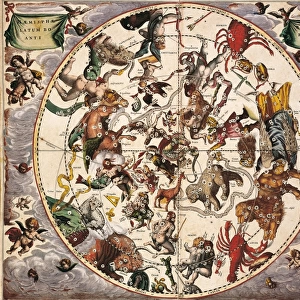
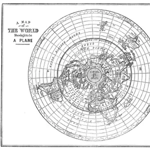
Map of Christian contellations, 1660-1661. Artist: Andreas Cellarius

![]()
Wall Art and Photo Gifts from Heritage Images
Map of Christian contellations, 1660-1661. Artist: Andreas Cellarius
Map of Christian contellations, 1660-1661. From The Celestial Atlas, or The Harmony of the Universe (Atlas coelestis seu harmonia macrocosmica) by Andreas Cellarius, published by Johannes Janssonius, (Amsterdam 1660-1661)
Heritage Images features heritage image collections
Media ID 15137858
© Historica Graphica Collection / Heritage-Images
Andreas Andreas Cellarius Astrology Cellarius Constellation Earth Orbit Planet Sign Space Star Sign Historica Graphica Collection
FEATURES IN THESE COLLECTIONS
> Arts
> Artists
> C
> Andreas Cellarius
> Europe
> Netherlands
> Amsterdam
> Europe
> Netherlands
> Maps
> Europe
> Netherlands
> Posters
> Europe
> Netherlands
> Related Images
> Maps and Charts
> Netherlands
> Maps and Charts
> Related Images
> Maps and Charts
> Star Charts
> Popular Themes
> Religious Images
> Science
> Space Exploration
> Planets
> Earth
EDITORS COMMENTS
This print showcases the "Map of Christian constellations" created by Andreas Cellarius in the 17th century. The intricate artwork, part of his renowned celestial atlas titled "The Harmony of the Universe" offers a fascinating glimpse into the intersection of astrology, astronomy, and Christianity during that era. Cellarius's map beautifully depicts the solar system and its planets orbiting around Earth. Each constellation is meticulously illustrated with vibrant colors, representing various religious symbols and figures significant to Christian beliefs. This unique blend of science and spirituality reflects the prevailing worldview at that time. As a Dutch artist, Cellarius contributed significantly to historical graphica collection with this masterpiece. Published by Johannes Janssonius in Amsterdam between 1660-1661, it remains an enduring testament to both artistic skill and scientific knowledge prevalent during the seventeenth century in Holland. The Map of Christian constellations not only serves as a visual representation but also invites contemplation on humanity's place within the cosmos. It reminds us how religion has influenced our understanding of space throughout history while highlighting our eternal fascination with stars and their significance in various cultures worldwide. This remarkable piece from Heritage Images captures an important chapter in human exploration where art meets science meets faith—a true treasure for enthusiasts interested in unraveling our collective journey through time and space.
MADE IN THE USA
Safe Shipping with 30 Day Money Back Guarantee
FREE PERSONALISATION*
We are proud to offer a range of customisation features including Personalised Captions, Color Filters and Picture Zoom Tools
SECURE PAYMENTS
We happily accept a wide range of payment options so you can pay for the things you need in the way that is most convenient for you
* Options may vary by product and licensing agreement. Zoomed Pictures can be adjusted in the Cart.