Home > Arts > Artists > D > Edward Dayes
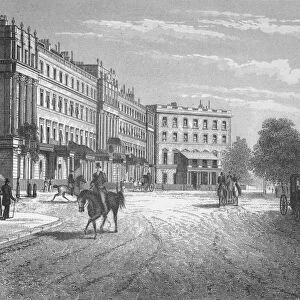
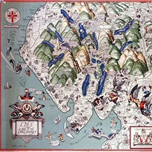
Map of Belgravia, 1814, (c1876). Creator: Unknown
. Creator: Unknown")
![]()
Wall Art and Photo Gifts from Heritage Images
Map of Belgravia, 1814, (c1876). Creator: Unknown
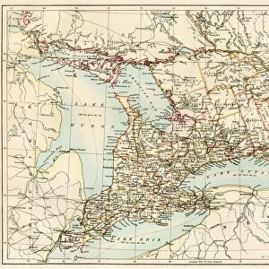
Map of Belgravia, 1814, (c1876). Developed in the early 19th century by Richard Grosvenor, 2nd Marquess of Westminster under the direction of Thomas Cubitt, Belgravia is one of the wealthiest districts in the world. From " Old and New London: A Narrative of Its History, Its People, and Its Places. The Western and Northern Studies", by Edward Walford. [Cassell, Petter, Galpin & Co. London, Paris & New York]
Heritage Images features heritage image collections
Media ID 19125801
© The Print Collector/Heritage Images
Affluent Belgravia Capital City Cassell Petter Galpin Cassell Petter Galpin Co Co Cassell Petter Galpin Edward Edward Walford Galpin And Co Georgian Grosvenor Kensington And Chelsea Knightsbridge London England United Kingdom Marquess Of Neighbourhood Old And New London Petter Petter And Galpin Richard Thom Thomas Cubitt Urbanisation Walford Walford Edward Wealth Wealthy West London Cassell City Of Westminster Sloane Street
FEATURES IN THESE COLLECTIONS
> Arts
> Artists
> D
> Edward Dayes
> Arts
> Artists
> D
> Thomas Day
> Arts
> Minimalist artwork
> Monochrome artwork
> Fine art
> Arts
> Minimalist artwork
> Monochrome artwork
> Monochrome paintings
> Asia
> Georgia
> Related Images
> Europe
> France
> Paris
> Maps
> Europe
> United Kingdom
> England
> London
> Boroughs
> City of Westminster
> Europe
> United Kingdom
> England
> London
> Boroughs
> Kensington and Chelsea
> Europe
> United Kingdom
> England
> London
> Towns
> Chelsea
EDITORS COMMENTS
This print showcases the "Map of Belgravia, 1814" which was developed in the early 19th century by Richard Grosvenor, 2nd Marquess of Westminster under the direction of Thomas Cubitt. Belgravia, depicted in this antique engraving, stands as one of the most affluent districts in the world. The monochrome image takes us on a journey through time to witness the grandeur and elegance that characterized this historic neighborhood. With its intricate details and precise cartography, this map offers a glimpse into London's past. Belgravia's prestigious reputation is evident as we explore its streets and avenues. The Georgian architecture exudes charm while reflecting the opulence that once defined this area. From Knightsbridge to Kensington and Chelsea, every lane tells a story of wealth and sophistication. Published in Edward Walford's renowned book "Old and New London: A Narrative of Its History, Its People, and Its Places" this print captures not only an exquisite piece of history but also serves as a testament to British heritage. As we admire this remarkable creation by an unknown artist from centuries ago, it reminds us that even though times have changed drastically since then, Belgravia still holds its allure as one of London's most sought-after neighborhoods. This print allows us to appreciate both the beauty captured within its borders and our connection with history itself.
MADE IN THE USA
Safe Shipping with 30 Day Money Back Guarantee
FREE PERSONALISATION*
We are proud to offer a range of customisation features including Personalised Captions, Color Filters and Picture Zoom Tools
SECURE PAYMENTS
We happily accept a wide range of payment options so you can pay for the things you need in the way that is most convenient for you
* Options may vary by product and licensing agreement. Zoomed Pictures can be adjusted in the Cart.