Home > Aerial Photography > Related Images
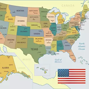
Garland Texas US City Street Map

![]()
Wall Art and Photo Gifts from Fine Art Storehouse
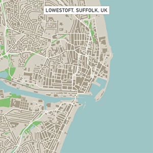
Garland Texas US City Street Map
Vector Illustration of a City Street Map of Garland, Texas, USA. Scale 1:60, 000.
All source data is in the public domain.
U.S. Geological Survey, US Topo
Used Layers:
USGS The National Map: National Hydrography Dataset (NHD)
USGS The National Map: National Transportation Dataset (NTD)
Unleash your creativity and transform your space into a visual masterpiece!
Frank Ramspott
Media ID 15192960
© Frank Ramspott, all rights reserved
Aerial View City Map Computer Graphic Directly Above Downtown District Garland Gray Road Map Texas Text Digitally Generated Image Green Color White Color
FEATURES IN THESE COLLECTIONS
> Aerial Photography
> Related Images
> Animals
> Insects
> Hemiptera
> Green Scale
> Arts
> Contemporary art
> Digital artwork
> Street art
> Arts
> Landscape paintings
> Waterfall and river artworks
> River artworks
> Arts
> Portraits
> Pop art gallery
> Street art portraits
> Arts
> Street art graffiti
> Digital art
> Digital paintings
> Arts
> Street art graffiti
> Digital art
> Vector illustrations
> Fine Art Storehouse
> Map
> Street Maps
> Fine Art Storehouse
> Map
> USA Maps
> Maps and Charts
> Geological Map
> Maps and Charts
> Related Images
> North America
> United States of America
> Lakes
> Related Images
EDITORS COMMENTS
This vibrant and detailed print showcases the city street map of Garland, Texas, USA. With a scale of 1:60,000, every intricate detail is captured in this vector illustration. The print features the downtown district, surrounded by a beautiful lake and river that add to the charm of this Texan city. Created using various layers from reliable sources such as USGS The National Map: National Hydrography Dataset (NHD) and USGS The National Map: National Transportation Dataset (NTD), this digitally generated image guarantees accuracy and reliability. All source data used in creating this masterpiece is in the public domain. The aerial view from directly above allows you to appreciate the layout of streets, roads, and highways that crisscross through Garland. The color scheme includes shades of gray, blue, white, and green which beautifully represent the physical geography of this dynamic city. Designed by Frank Ramspott for Fine Art Storehouse's collection, this piece is perfect for anyone who appreciates cartography or wants to showcase their love for Garland. With no people present in the image itself but accompanied by text indicating its origin and authorship details discreetly at one corner - it truly captures the essence of an urban landscape frozen in time.
MADE IN THE USA
Safe Shipping with 30 Day Money Back Guarantee
FREE PERSONALISATION*
We are proud to offer a range of customisation features including Personalised Captions, Color Filters and Picture Zoom Tools
SECURE PAYMENTS
We happily accept a wide range of payment options so you can pay for the things you need in the way that is most convenient for you
* Options may vary by product and licensing agreement. Zoomed Pictures can be adjusted in the Cart.