Home > Europe > United Kingdom > England > South Yorkshire > Sheffield
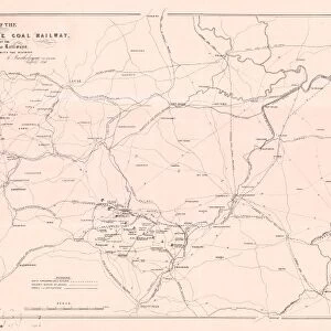
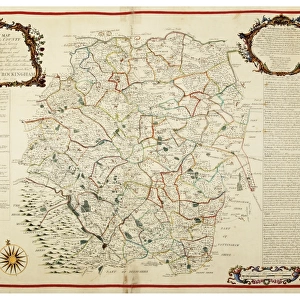
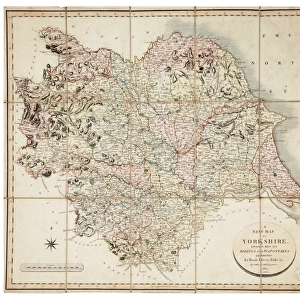
Plan showing the connexion of canals and navigable rivers by the proposed north-eastern Canal, 19th cent

![]()
Wall Art and Photo Gifts from Sheffield City Archives
Plan showing the connexion of canals and navigable rivers by the proposed north-eastern Canal, 19th cent
By C. Smith, Strand.
From Bristol in the south to York in the north, Liverpool in the west and Hull in the east)
From an original at Sheffield Libraries: arc02904
Sheffield City Archives and Local Studies Library has an unrivalled collection of images of Sheffield, England
Media ID 19192276
© Sheffield City Council
Canals Sheffield York Yorkshire Bristol Hull
FEATURES IN THESE COLLECTIONS
> Europe
> United Kingdom
> England
> Bristol
> Bristol
> Europe
> United Kingdom
> England
> North Yorkshire
> Related Images
> Europe
> United Kingdom
> England
> North Yorkshire
> York
> Europe
> United Kingdom
> England
> South Yorkshire
> Related Images
> Europe
> United Kingdom
> England
> South Yorkshire
> Sheffield
> Europe
> United Kingdom
> England
> West Yorkshire
> Related Images
> Europe
> United Kingdom
> England
> Yorkshire
> Hull
> Europe
> United Kingdom
> England
> Yorkshire
> Related Images
> Europe
> United Kingdom
> England
> Yorkshire
> Sheffield
> Sheffield City Archives
> Maps and Plans
EDITORS COMMENTS
This print showcases a remarkable plan from the 19th century, illustrating the intricate network of canals and navigable rivers in England. Created by C. Smith, this detailed map reveals the proposed north-eastern Canal, connecting various prominent cities across the country. From bustling Bristol in the south to historic York in the north, vibrant Liverpool in the west to thriving Hull in the east, this ambitious canal system aimed to revolutionize transportation and trade. The print originates from Sheffield Libraries' extensive archives (arc02904), offering a glimpse into an era when waterways played a vital role in shaping economic development and connectivity. The sheer scale of this plan is awe-inspiring as it highlights how these cities were envisioned to be linked through an extensive web of canals. While commercial use may not be mentioned explicitly here, it is impossible to overlook its potential impact on trade and commerce during that time period. This photograph serves as a testament to human ingenuity and ambition as people sought innovative ways to connect distant regions for mutual benefit. As we admire this historical document preserved within Sheffield City Archives, let us appreciate both its artistic beauty and significance as a symbol of progress that once captivated minds across Yorkshire and beyond.
MADE IN THE USA
Safe Shipping with 30 Day Money Back Guarantee
FREE PERSONALISATION*
We are proud to offer a range of customisation features including Personalised Captions, Color Filters and Picture Zoom Tools
SECURE PAYMENTS
We happily accept a wide range of payment options so you can pay for the things you need in the way that is most convenient for you
* Options may vary by product and licensing agreement. Zoomed Pictures can be adjusted in the Cart.