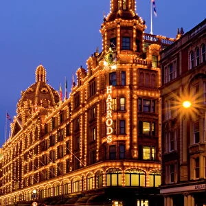
Home > Europe > United Kingdom > England > London > Sights > Harrods
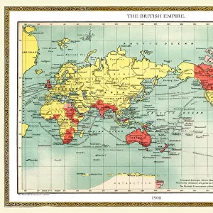
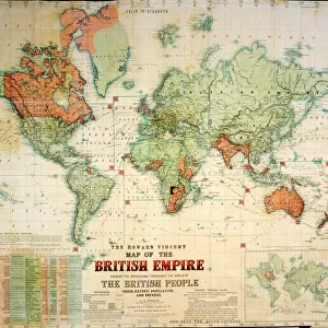
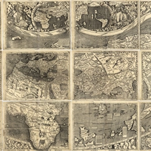
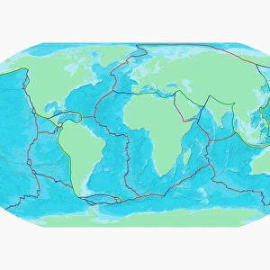
Harrods advert world map, c. 1909

![]()
Wall Art and Photo Gifts from Mary Evans Picture Library
Harrods advert world map, c. 1909
A world map, advertising Harrods department store, touted here as the supply centre of the British Empire. Land belonging to the British Empire is marked in red, with the flagship London store appearing in a vignette. Date: 1909
Mary Evans Picture Library makes available wonderful images created for people to enjoy over the centuries
Media ID 14123793
© Mary Evans Picture Library
Department Harrods Knightsbridge Store
FEATURES IN THESE COLLECTIONS
> Europe
> France
> Canton
> Landes
> Europe
> United Kingdom
> England
> London
> Museums
> British Library
> Europe
> United Kingdom
> England
> London
> Related Images
> Europe
> United Kingdom
> England
> London
> Sights
> Harrods
> Maps and Charts
> British Empire Maps
> Maps and Charts
> Early Maps
> Maps and Charts
> Related Images
> Maps and Charts
> World
EDITORS COMMENTS
This world map, hailing from the year 1909, serves as an intriguing snapshot of Harrods Department Store's ambitious marketing strategy during the Edwardian era. The map, adorned with the Harrods logo and the tagline "Harrods, the Supply Centre of the British Empire," presents a vivid representation of the vast territories under British rule, denoted by the distinctive red hue. At the heart of this global network lies the flagship Harrods store, located in Knightsbridge, London, depicted in a charming vignette. The map not only underscores Harrods' commitment to catering to the needs of the British Empire but also showcases the extent of its reach and influence. The intricate details on this map are a testament to the meticulous craftsmanship of the time. From the labyrinthine railways and shipping routes to the precise demarcation of colonial territories, each element contributes to the overall allure of this historical artifact. As we delve deeper into the map, we are transported back to an era of imperial grandeur and commercial prowess. The Harrods world map of 1909 stands as a tangible reminder of the British Empire's global dominance and the role that Harrods played in supplying its far-flung territories. This enchanting piece of advertising history not only offers a glimpse into the past but also serves as a fascinating study of the intricate relationship between commerce, imperialism, and cartography during the early 20th century.
MADE IN THE USA
Safe Shipping with 30 Day Money Back Guarantee
FREE PERSONALISATION*
We are proud to offer a range of customisation features including Personalised Captions, Color Filters and Picture Zoom Tools
SECURE PAYMENTS
We happily accept a wide range of payment options so you can pay for the things you need in the way that is most convenient for you
* Options may vary by product and licensing agreement. Zoomed Pictures can be adjusted in the Cart.