Home > Europe > United Kingdom > Scotland > East Lothian > Haddington
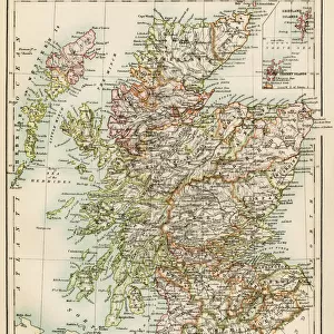
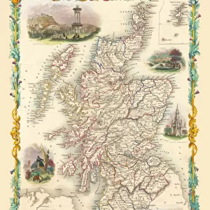
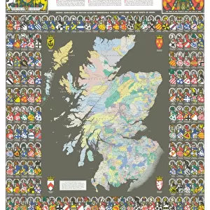
Old County Map of Haddington Scotland 1847 by A&C Black

![]()
Wall Art and Photo Gifts from MapSeeker
Old County Map of Haddington Scotland 1847 by A&C Black
A finely detailed facimile remastered in full colour from an antique original map of Haddington featured in A&C Blacks Atlas of 1847. Each Parish is numbered using an index table, colour rendition beautifully differentiating all of the Parishes. As well as principal roads, towns, villages and hamlets, these county maps of Scotland feature key battle sites marked with two crossed swords and the date of the battle
Welcome to the Mapseeker Image library and enter an historic gateway to one of the largest on-line collections of Historic Maps, Nostalgic Views, Vista's and Panorama's from a World gone by.
Media ID 20347463
© Mapseeker Publishing Ltd
A And C Black A And C Black Atlas A And C Black Map County Map County Map Of Scotland Historic Map Old County Map Old Scottish County Map Scottish County Map Haddington Haddingtonshire
FEATURES IN THESE COLLECTIONS
> Arts
> Photorealistic artworks
> Detailed art pieces
> Masterful detailing in art
> Europe
> United Kingdom
> Scotland
> East Lothian
> Haddington
> Europe
> United Kingdom
> Scotland
> Haddingtonshire
> Europe
> United Kingdom
> Scotland
> Lothian
> Haddington
> Europe
> United Kingdom
> Scotland
> Maps
> Historic
> Battles
> Related Images
> Maps and Charts
> Early Maps
> Maps and Charts
> Related Images
> MapSeeker
> Maps from the British Isles
> Scotland and Counties PORTFOLIO
EDITORS COMMENTS
Step back in time with this exquisitely detailed Old County Map of Haddington, Scotland from 1847. Remastered in full color, this facsimile print captures the beauty and intricacy of an antique original map featured in A&C Black's Atlas. With each Parish numbered using an index table, this map provides a comprehensive view of Haddingtonshire's landscape. The vibrant colors elegantly differentiate between all the Parishes, making it easy to navigate through towns, villages, and hamlets. What sets these county maps apart are the significant battle sites marked by two crossed swords and their respective dates. This feature adds a historical dimension to the map, allowing you to trace Scotland's rich military heritage. Transport yourself to another era as you explore principal roads winding through picturesque landscapes. Immerse yourself in the history of Haddington as you follow its development over time. This historic map is not just a visual delight but also serves as a valuable resource for researchers and enthusiasts alike. Whether you're tracing your family roots or simply curious about Haddingtonshire's past, this meticulously crafted print offers a fascinating glimpse into Scottish history. Displaying exceptional attention to detail and capturing the essence of its era, this Old County Map of Haddingtonshire by A&C Black is truly an exquisite piece that will transport any admirer back to 19th-century Scotland.
MADE IN THE USA
Safe Shipping with 30 Day Money Back Guarantee
FREE PERSONALISATION*
We are proud to offer a range of customisation features including Personalised Captions, Color Filters and Picture Zoom Tools
SECURE PAYMENTS
We happily accept a wide range of payment options so you can pay for the things you need in the way that is most convenient for you
* Options may vary by product and licensing agreement. Zoomed Pictures can be adjusted in the Cart.