Home > Europe > United Kingdom > Wales > Gwent > Newport
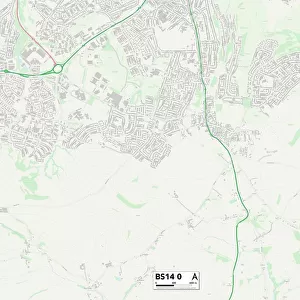
Newport NP20 5 Map

![]()
Wall Art and Photo Gifts from Map Marketing
Newport NP20 5 Map
Postcode Sector Map of Newport NP20 5
Media ID 19976900
Adelaide Street Albany Street Argyle Street Brynglas Campion Close Canal Street Canterbury Close Comfrey Close Coriander Close Edwin Street Enville Road Evans Street Factory Road Fields Road Glastonbury Close Highcroft Road Kings Acre Lambert Close Lambert Street Ledbury Drive Lucas Street Malmesbury Close Meadow Close Mill Street Newport Prospect Street Queens Close Redbrook Road Ridgeway Ridgeway Avenue Ridgeway Close Ridgeway Drive Ridgeway Gardens Rose Street Ross Street Salisbury Close Shaftesbury Street Shrewsbury Close Sorrel Drive Spring Street St Marks Crescent Sycamore Drive Woodville Road Wyndham Street Barrack Hill Marshes Pentonville
FEATURES IN THESE COLLECTIONS
> Europe
> United Kingdom
> Wales
> Gwent
> Newport
> Europe
> United Kingdom
> Wales
> Pembrokeshire
> Newport
> Map Marketing
> Postcode Sector Maps
> NP - Newport
> Maps and Charts
> Related Images
MADE IN THE USA
Safe Shipping with 30 Day Money Back Guarantee
FREE PERSONALISATION*
We are proud to offer a range of customisation features including Personalised Captions, Color Filters and Picture Zoom Tools
SECURE PAYMENTS
We happily accept a wide range of payment options so you can pay for the things you need in the way that is most convenient for you
* Options may vary by product and licensing agreement. Zoomed Pictures can be adjusted in the Cart.