Home > Europe > United Kingdom > England > London > Transport > Underground
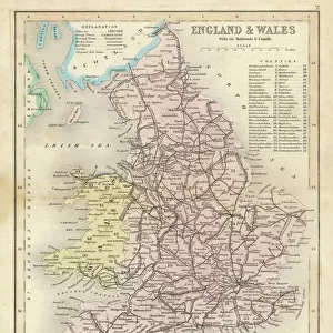
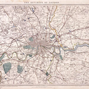
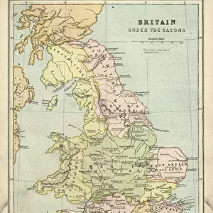
Map of Greater London showing the Metropolitan Railways and improvements in 1866

![]()
Wall Art and Photo Gifts from Heritage Images
Map of Greater London showing the Metropolitan Railways and improvements in 1866
Map of Greater London showing the Metropolitan Railways and improvements in 1866. With a table inset listing the proposed lines. Completed railways are shown in a firm black line, with those in progress or sanctioned represented by a pecked black line. Proposed new lines are shown in red
Heritage Images features heritage image collections
Media ID 15176032
© London Metropolitan Archives (City of London) / Heritage-Images
London Transport London Underground Metropolitan Railway Plan Proposal Public Transport Railway Line Route
FEATURES IN THESE COLLECTIONS
> Europe
> United Kingdom
> England
> Greater London
> Related Images
> Europe
> United Kingdom
> England
> London
> Boroughs
> City of London
> Europe
> United Kingdom
> England
> London
> Transport
> Underground
> Europe
> United Kingdom
> England
> Maps
> Europe
> United Kingdom
> England
> Railways
> Maps and Charts
> Related Images
> Popular Themes
> Railway Posters
EDITORS COMMENTS
This 19th-century lithograph showcases a detailed "Map of Greater London showing the Metropolitan Railways and improvements in 1866". The print, held at the Guildhall Library and Art Gallery, offers a fascinating glimpse into the transportation landscape of Victorian England. The map is adorned with vibrant colors, highlighting completed railways in a firm black line and those still under construction or sanctioned by a pecked black line. Additionally, proposed new lines are depicted in striking red, providing insight into the ambitious plans for expanding London's public transport network during this era. A table inset accompanies the map, listing all the proposed lines that were intended to enhance connectivity across the city. This visual representation not only serves as an informative tool but also reflects the meticulous attention to detail characteristic of cartography from that time. As we explore this historical artifact further, it becomes evident that this lithograph was created anonymously. However, its significance lies not in its authorship but rather in its ability to transport us back to a pivotal moment in London's transportation history. This remarkable piece captures both the progress made by existing railway lines and future aspirations for expansion within Greater London. It stands as a testament to human ingenuity and ambition while offering valuable insights into how public transportation shaped one of the world's greatest cities during this transformative period.
MADE IN THE USA
Safe Shipping with 30 Day Money Back Guarantee
FREE PERSONALISATION*
We are proud to offer a range of customisation features including Personalised Captions, Color Filters and Picture Zoom Tools
SECURE PAYMENTS
We happily accept a wide range of payment options so you can pay for the things you need in the way that is most convenient for you
* Options may vary by product and licensing agreement. Zoomed Pictures can be adjusted in the Cart.