Home > Europe > Austria > Heritage Sites > Historic Centre of the City of Salzburg
Map of the Austro-Italian frontier, First World War, (c1920). Creator: John Bartholomew & Son
. Creator: John Bartholomew & Son")
![]()
Wall Art and Photo Gifts from Heritage Images
Map of the Austro-Italian frontier, First World War, (c1920). Creator: John Bartholomew & Son
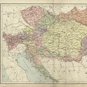
Map of the Austro-Italian frontier, First World War, (c1920). Mountainous area between Salzburg, Trieste and Cremona, showing the Tyrol. From " The Great World War - A History" Volume III, edited by Frank A Mumby. [The Gresham Publishing Company Ltd, London, c1920]
Heritage Images features heritage image collections
Media ID 19175539
© The Print Collector/Heritage Images
Alps Austria Hungary Austro Hungarian Bartholomew Bartholomew And Co Bartholomew Co Bartholomew John Son Border Borders Frank Arthur Frank Arthur Mumby Friuli Venezia Giulia Frontier Frontiers Gresham Publishing Co Ltd Gresham Publishing Company Jg Bartholomew John And Son John Bartholomew And Co John Bartholomew And Son John Bartholomew And Son Ltd John Bartholomew Co John Bartholomew Son John Bartholomew Son Ltd John Son Keystone Archives Lake Garda Mountain Range Mumby Mumby Frank Arthur Salzburg Salzburg Austria Switzerland The Alps The Great World War A History Theatre Of War Trieste Tyrol Venice Venice Italy
FEATURES IN THESE COLLECTIONS
> Europe
> Austria
> Heritage Sites
> Historic Centre of the City of Salzburg
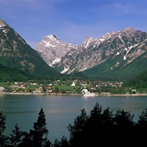
> Europe
> Austria
> Lakes
> Related Images
> Europe
> Austria
> Related Images
> Europe
> Hungary
> Lakes
> Related Images
> Europe
> Hungary
> Related Images
EDITORS COMMENTS
This print showcases a detailed map of the Austro-Italian frontier during the First World War. Created by John Bartholomew & Son around 1920, this historical artifact provides a glimpse into the mountainous region between Salzburg, Trieste, and Cremona, highlighting the Tyrol area. The map is featured in "The Great World War - A History". Volume III, edited by Frank A Mumby and published by The Gresham Publishing Company Ltd in London. With its vibrant colors and intricate details, this map offers an invaluable resource for understanding the geographical features and borders that played a significant role in shaping the events of the war. It captures not only the physical landscape but also represents crucial political boundaries between Austria-Hungary and Italy during that time. From Lake Garda to Friuli Venezia Giulia, every corner of this region is meticulously depicted on this print. The majestic Alps dominate much of the scenery, serving as both a natural barrier and a theater of war throughout history. John Bartholomew & Son's expertise in cartography shines through their meticulous craftsmanship evident in every line and contour presented on this stunning piece. Whether you are a history enthusiast or simply fascinated by maps, this print transports you back to an era when nations clashed amidst breathtaking landscapes.
MADE IN THE USA
Safe Shipping with 30 Day Money Back Guarantee
FREE PERSONALISATION*
We are proud to offer a range of customisation features including Personalised Captions, Color Filters and Picture Zoom Tools
SECURE PAYMENTS
We happily accept a wide range of payment options so you can pay for the things you need in the way that is most convenient for you
* Options may vary by product and licensing agreement. Zoomed Pictures can be adjusted in the Cart.