Home > Europe > United Kingdom > Scotland > Edinburgh > Edinburgh
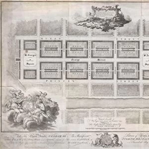
Map: Plan of the Town and Borough of Liverpool, with Birkenhead, Tranmere, Seacombe, New Brighton etc, from the ordnance and other surveys, by J Bartholomew, Edinburgh (colour litho)
")
![]()
Wall Art and Photo Gifts from Fine Art Finder
Map: Plan of the Town and Borough of Liverpool, with Birkenhead, Tranmere, Seacombe, New Brighton etc, from the ordnance and other surveys, by J Bartholomew, Edinburgh (colour litho)
6004737 Map: Plan of the Town and Borough of Liverpool, with Birkenhead, Tranmere, Seacombe, New Brighton etc, from the ordnance and other surveys, by J Bartholomew, Edinburgh (colour litho) by English School, (19th century); Private Collection; (add.info.: Plan of the Town and Borough of Liverpool, with Birkenhead, Tranmere, Seacombe, New Brighton etc, from the ordnance and other surveys, by J Bartholomew, Edinburgh. Illustration for A Gazetteer of the World or Dictionary of Geographical Knowledge (A Fullarton, 1858).); © Look and Learn
Media ID 23286036
© Look and Learn / Bridgeman Images
1850s Birkenhead Borough Brighton Brighton Beach Edinburgh Liverpool New Brighton Ordnance Surveys Victoria Seacombe Tranmere
FEATURES IN THESE COLLECTIONS
> Europe
> United Kingdom
> Heritage Sites
> Old and New Towns of Edinburgh
> Europe
> United Kingdom
> Scotland
> Edinburgh
> Edinburgh
> Europe
> United Kingdom
> Scotland
> Lothian
> Edinburgh
> Fine Art Finder
> Artists
> English Photographer
> Fine Art Finder
> Artists
> English School
> Maps and Charts
> Early Maps
> Maps and Charts
> Related Images
> Maps and Charts
> World
EDITORS COMMENTS
This vibrant and detailed print captures a historical map of Liverpool, showcasing the town and borough along with its surrounding areas such as Birkenhead, Tranmere, Seacombe, and New Brighton. Created by J Bartholomew in Edinburgh during the 19th century, this colour lithograph offers a fascinating glimpse into the past. The map was originally featured in A Gazetteer of the World or Dictionary of Geographical Knowledge published by Fullarton in 1858. It served as an essential tool for understanding the geography and layout of Liverpool during that time period. With its intricate design and meticulous attention to detail, this map provides valuable insights into the history and development of these areas. From bustling streets to serene beaches like Brighton Beach, it showcases how Liverpool evolved throughout the mid-19th century under Queen Victoria's reign. Whether you are a history enthusiast or simply intrigued by cartography, this print is sure to captivate your imagination. Its rich colors bring life to each street corner while highlighting significant landmarks and points of interest. Preserved within a private collection but made accessible through Bridgeman Images' Fine Art Finder platform, this piece allows us to explore Liverpool's past from our own homes. Step back in time with this remarkable visual representation that intertwines artistry with geographical knowledge.
MADE IN THE USA
Safe Shipping with 30 Day Money Back Guarantee
FREE PERSONALISATION*
We are proud to offer a range of customisation features including Personalised Captions, Color Filters and Picture Zoom Tools
SECURE PAYMENTS
We happily accept a wide range of payment options so you can pay for the things you need in the way that is most convenient for you
* Options may vary by product and licensing agreement. Zoomed Pictures can be adjusted in the Cart.